 Southern NV Pahrump-area Brothels (Chicken Ranch & Sheri's Ranch): Southern NV Pahrump-area Brothels (Chicken Ranch & Sheri's Ranch):
 How to get to the Pahrump brothels from:
Las Vegas :
Detailed Directions (describing alternatives)
Quick Directions:
· Gamebird (traditional) Route
· Manse/Turner (shortest) Route
· Manse/Homestead (avoid School Zone) Route
· C.A.A.S./Kellogg (original "back") Route
Southern California :
Detailed Directions (describing alternatives)
Quick Directions:
· Baker/Shoshone (recommended) Route
· Baker/Tecopa Route
· via Las Vegas Route
Return to the top
Pahrump Brothels:
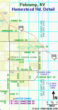
The Chicken Ranch and Leghorn Bar
10511 Homestead Road
Pahrump, NV
Website:
http://www.chickenranchbrothel.com
Phone Numbers:
(877) 585-2397 toll-free
(702) 382-7870 from Las Vegas
(775) 727-5721 from Pahrump
GPS Information:
Coordinates: 36° 04' 24.7"N -- 115° 57' 23.45"W
Elevation: 2606'
The World-Famous Chicken Ranch (or "CR" for short) is on the left (east) side of Homestead Road, just a block south of its intersection with Silver Street (where an airstrip for the Ranch used to run to the east along the northern edge of the property) and about 3 miles south of the branch Post Office on the southwest corner of Homestead's intersection with Kellogg Road. In 2002, then-majority owners Russ Reade and Ken Green changed their establishment's long-standing policy of not having an Internet presence and comissioned a website. This bordello takes its name and legacy (and is also the home to certain memorabilia) from the famous, but long-since closed, original Chicken Ranch in LaGrange, TX. Renovations to the CR's parlor have made it very luxurious and homey, long gone are the infamous plastic seat-covered sofas. The attached Leghorn Bar has also undergone a complete facelift and major expansion, completed in the late summer of 2011. Many well-known figures, both customers and courtesans, have walked the legendary maze of hallways of the Chicken Ranch, as this house has enjoyed a stellar reputation over the many years it has operated in Pahrump). The present owners had reached an agreement for a sale of the CR in 2006; however, Nye County regulators rejected the purchasing ownership group's application for licensing and the sale subsequently fell through. In 2007, the ranch and a few of its working ladies and staff at that time were featured in a documentary mini-series on the Sundance Channel, titled Pleasure for Sale. By 2011 the house no longer routinely featured the huge number of ladies it had in its lineups during the late 1990s, but those who do choose to work there are all first-class (including the reigning CWMC Courtesan of the Year© for 2010) and these beautiful, skilled women cater to gentlemen, single ladies, and couples of all means.
The Resort at Sheri's Ranch and the Valley Inn Sports Bar
10551 Homestead Road
Pahrump, NV
Website:
http://www.sherisranch.net
Phone Numbers:
(866) 820-9100 toll-free
(702) 387-0500 from Las Vegas
(775) 751-5111 from Pahrump
GPS Information:
Coordinates: 36° 04' 14.65"N -- 115° 57' 23.85"W
Elevation: 2605'
Sheri's is just two blocks south of the Chicken Ranch, also on the left (east) side of Homestead, and sits at the end of the paved road, which will conveniently deposit you into their parking lot. Since a major renovation and expansion took place in 2001-02, Sheri's many rooms and luxurious facilities entice working ladies and customers alike. Chuck Lee, lead spokesperson for Sheri's ownership group at the time, announced big plans for further development of the property back in the mid-2000s, and the group has subsequently added a small on-site hotel (see their website for details). Though plans to add a golf course on the surrounding property have been postponed indefinitely (if not cancelled outright), they nonetheless seem to have met their original goal of creating (in their words) "a true world-class adult resort." During the Great Recession of 2008-2010, the owners of Sheri's ran into financial difficulties and the property was placed up for sale at an auction in August of 2009. However, since no qualified bidders met the minimum purchase price, the ranch was not sold at that time. It still remains in business today under the same ownership group (long rumored to be a group of ex-NFL players wishing to remain relatively anonymous). Recent managament changes and turnover in the ladies choosing to work there have eliminated most of the negative reputation this house had in the mid-2000s for only catering to "big spenders". Customers of all means now feel more welcome to enjoy the lavish facilities and numerous stunning and talented ladies that Sheri's has to offer.
GPS coordinates & elevation data courtesy of Bashful
Return to the top
Return to the Southern Nevada index
Return to directions index
Pahrump Maps:
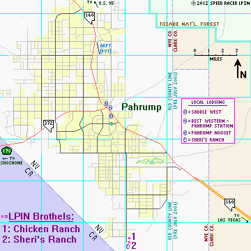
Notes on Pahrump intersections:
There is a traffic signal at the intersection of S.R. 160 and Homestead/Winery. There are 4-Way STOP signs at the intersections of Homestead & Gamebird (Homestead is free-flowing south of that point, all traffic on cross-streets and side streets must STOP), as well as at Manse & Hafen Ranch. When on eastbound S.R. 160 (heading southeast from the center of town), as you approach Calavada Boulevard the right lane (#2) becomes right turn only (lane drop), so stay in the left lane (#1) if you wish to continue on along 160 to Homestead or beyond.
Return to the top
How to get to the Pahrump brothels from Las Vegas:
| From | Miles | To | Notes/Action(s) |
|---|---|---|---|
| I-15 southbound @I-215/C.R. 215 (Woodbury Beltway) | 1.05 | I-15 SB @exit #33 ramp to Blue Diamond Rd (NV 160) | Take exit #33 - Pahrump / Blue Diamond |
| Exit #33 ramp to Blue Diamond Rd (NV 160) @exit point from SB I-15 | 0.70* | Blue Diamond Rd (NV 160) @Dean Martin Dr |
Use right lane on ramp; then merge left onto WB NV 160 before 1st stoplight @Dean Martin |
| * = Note: exact mileage may vary slightly due to the 2007 recofiguration of this interchange | |||
| Blue Diamond Rd (NV 160) @Dean Martin Dr |
10.03 | Pahrump Hwy (NV 160) @Blue Diamond Rd (Jct NV 159/160) |
Continue straight ahead on WB NV 160 |
| Pahrump Hwy (NV 160) @Blue Diamond Rd (Jct NV 159/160) |
32.22 | Pahrump Valley Hwy (NV 160) @Clark - Nye County Line |
Having continued west over Mtn Sprgs Summit, then northwest, all on NV 160 |
| Pahrump Valley Hwy (NV 160) @Clark - Nye County Line |
4.43 | NV 160 @Gamebird Rd | Turn left @Gamebird, proceed west |
| Gamebird Rd @NV 160 | 2.98 | Gamebird Rd @Homestead Rd (4-way STOP sign here) |
Turn left @Homestead, proceed south |
| Homestead Rd @Gamebird Rd | 6.11 | Chicken Ranch 10511 Homestead Rd |
Turn left into CR's parking lot |
| Or continue on Homestead Rd | 0.15 | Sheri's Ranch 10551 Homestead Rd |
Turn left into Sheri's parking lot, before end of pavement |
Return to the top
Return to the Southern Nevada index
Return to directions index
(1) Get on I-15 southbound (toward Los Angeles) and proceed to exit #33: Blue Diamond Road (NV 160 - Pahrump) on the south side of Las Vegas. The first stoplight, west of those for this exit, is at Dean Martin Drive (prior to 2005/10/07 known as Industrial Road), just past the Silverton Hotel on your left. Use the right lane(s) on the freeway exit ramp to merge directly onto westbound Blue Diamond Road, but immediately past that merge point, you should bear left to get to one of the four through lanes of Nevada 160 (the rightmost lane(s) will become turn lanes for motorists wishing to get to northbound Dean Martin Drive at the stoplight, a mere one block later).
(2) Follow NV 160 west-southwest, across the recently constructed bridge over the Union Pacific railroad, past the stoplight at Rainbow Boulevard (unsigned NV 595), past the new traffic signal and intersection for the recently-extended Durango Drive, to the junction with NV 159 (which goes to the town of Blue Diamond & the Red Rock Canyon beyond). I now label this particular unsignalized intersection as the "Las Vegas gateway", the single point which all of the possible alternative routes in the metro area have in common for this particular journey. It is 10.03 miles distant from the stoplight at Dean Martin Dr, 6.68 miles from the one at Rainbow Blvd, and 4.66 miles from the signal at Durango Dr.
Note: Work Zone on Nevada S.R. 160 (updated 2011/10/21):
In this and all active construction zones, please slow down and be very careful to keep a sharp lookout for construction workers, who are merely trying to stay alive and earn a living while improving these roads for the future safety and convienence of all.
 The approximately five mile stretch of highway 160 between Durango Drive and the junction with Nevada S.R. 159 is at present being widened. While most of the work at this time is on along the shoulders on both sides of the existing 2-lane road, please watch out for workers, trucks, and construction equipment in the area. Slight delays as well as slow or stopped traffic may be encountered, so be alert for flaggers and please obey their instructions.
At the southwest edge of the metro area, Blue Diamond Rd leaves S.R. 160 to the right, becoming State Route 159 then passing through its namesake town and past the mine that burg was named for (S.R. 159 eventually loops back into Las Vegas as Charleston Blvd after passing through the most scenic portions of the Red Rock Canyon National Conservation Area). Nevada S.R. 160 proceeds straight ahead here and becomes known as the Pahrump Highway west of this intersection. Remain on highway 160 and continue west-southwest into the Spring Mountains. After curving up and over the Mountain Springs Summit (elevation 5493'), the road will become a full divided highway just past that crest. You will then swing to the northwest, pass the junction with the Old Spanish Trail Highway (which leads west to Tecopa, CA and is, as of october 2011, now resigned as "Tecopa Rd"), and eventually reach the Clark - Nye County Line (near the intersection of Trout Canyon Rd), a total of about 32.22 miles from the Las Vegas gateway point (the aforementioned junction of highways 159 & 160).
(3) At the county line (which is the "gateway point" at the Pahrump end of this journey), you now have several options (plus additional alternatives if you miss certain turns):
Notes:
If you turned west off 160 at C.A.A.S. Road, follow it across the old (pre-2001) county line for 0.62 miles, where it then makes a sharp 90° curve to the left (south) and becomes Hafen Ranch Road. Continue, another 0.23 (total of 0.85 from NV 160) to a 4-Way STOP sign at Manse Rd. Here, you can proceed straight south and then follow "Hafen Ranch route" (option 1) detailed above or turn right (west) onto Manse and follow the rest of the "Manse/Homestead route" (option 2).
Unless you're closely watching your odometer, when returning to Las Vegas from the brothels you might wish to use the Kellogg alternative, especially at night, as the Post Office branch makes much a better landmark to spot the turn at Kellogg since there's still not much (yet) to distinguish the corner of Homestead and Turner other than the small street sign.
The last service station between Las Vegas and Pahrump is at the junction with NV 159 (where Blue Diamond Road splits off); west of this point, the road's name becomes Pahrump Highway (but the designation remains NV 160). About the only civilization between these points consists of a few scattered homes, a fire station, and a saloon, most of which are near the Mountain Springs Summit. There is a passing lane for westbound traffic as you climb into the Mountain Springs area (and the climb eastbound is on a 4-lane divided highway), but there is only one lane on the eastbound descent (and in both directions at the summit). This is not a difficult mountainous road, but can be dangerous because of high traffic volume and impatient or distracted, unattentive drivers. The weather is rarely a problem, except for some occasional fog or patchy ice/snow in winter (and, of course, the desert heat throughout the region in summer). Once you're a couple of miles past the summit westbound, the road becomes a 4-lane divided facility with a 70 M.P.H. speed limit until you approach Pahrump. It is highly recommended that you observe the posted speed limits carefully on all segments of this highway; while most of it is rather remote, it still has a very high volume of commuter and truck traffic, accidents due to distracted drivers are still quite common, and it is patrolled quite frequently. Relax and enjoy this scenic drive, safely!
For you road geek types, know that the "official name" of S.R. 160 changes again (slightly) at the county line. Pahrump Highway (Clark County) becomes Pahrump Valley Highway (Nye County), but the designation remains Nevada State Route 160 in both juristictions.
As you cross into Nye County and near Pahrump, there are now quite a few alternative routes available to save you a few miles and/or avoid traffic trouble spots. The original "secret back" route, using C.A.A.S. Road to Kellogg Road is only a couple tenths of a mile shorter than the traditional Gamebird Road route, and has a couple of extra turns, but has the distinct advantage of avoiding the accident-prone stretch of Homestead Road around Terrible's Lakeside Casino. An even shorter route is now available, uning the relatively new Manse Road extension to Hafen Ranch Road, then continuing south at Kellogg past the elementery school (15 MPH during school hours) onto Indian Reservation Road and Turner Boulevard. This routing saves another quarter mile or so over the "classic" C.A.A.S./Kellogg shortcut. And if you wish to avoid the school zone altogether, you can remain on Manse (or turn right, if you used C.A.A.S.) past the 4-Way STOP at Hafen Ranch and head west to Homestead.
Confused yet? Just check the maps above!
| From | Miles | To | Notes/Action(s) |
|---|---|---|---|
| I-15 southbound @I-215/C.R. 215 (Woodbury Beltway) | 1.05 | I-15 SB @exit #33 ramp to Blue Diamond Rd (NV 160) | Take exit #33 - Pahrump / Blue Diamond |
| Exit #33 ramp to Blue Diamond Rd (NV 160) @exit point from SB I-15 | 0.70* | Blue Diamond Rd (NV 160) @Dean Martin Dr |
Use right lane on ramp; then merge left onto WB NV 160 before 1st stoplight @Dean Martin |
| * = Note: exact mileage may vary slightly due to the 2007 recofiguration of this interchange | |||
| Blue Diamond Rd (NV 160) @Dean Martin Dr |
10.03 | Pahrump Hwy (NV 160) @Blue Diamond Rd (Jct NV 159/160) |
Continue straight ahead on WB NV 160 |
| Pahrump Hwy (NV 160) @Blue Diamond Rd (Jct NV 159/160) |
32.22 | Pahrump Valley Hwy (NV 160) @Clark - Nye County Line |
Having continued west over Mtn Sprgs Summit, then northwest, all on NV 160 |
| Pahrump Valley Hwy (NV 160) @Clark - Nye County Line |
2.55 | NV 160 @Manse Rd | Turn left @Manse |
| Manse Rd @NV 160 | 1.09 | Manse Rd @Hafen Ranch Rd (4-Way STOP sign here) |
Turn left @Hafen Ranch |
| Hafen Ranch Rd @Manse Rd | 5.59 | Turner Blvd @Homestead Rd (STOP sign here) |
Follow Hafen Ranch thru 2 right curves (becomes Turner); turn left @Homestead |
| Homestead Rd @Turner Blvd | 2.05 | Chicken Ranch 10511 Homestead Rd |
Turn left into CR's parking lot |
| Or continue on Homestead Rd | 0.15 | Sheri's Ranch 10551 Homestead Rd |
Turn left into Sheri's parking lot |
| From | Miles | To | Notes/Action(s) |
|---|---|---|---|
| I-15 southbound @I-215/C.R. 215 (Woodbury Beltway) | 1.05 | I-15 SB @exit #33 ramp to Blue Diamond Rd (NV 160) | Take exit #33 - Pahrump / Blue Diamond |
| Exit #33 ramp to Blue Diamond Rd (NV 160) @exit point from SB I-15 | 0.70* | Blue Diamond Rd (NV 160) @Dean Martin Dr |
Use right lane on ramp; then merge left onto WB NV 160 before 1st stoplight @Dean Martin |
| * = Note: exact mileage may vary slightly due to the 2007 recofiguration of this interchange | |||
| Blue Diamond Rd (NV 160) @Dean Martin Dr |
10.03 | Pahrump Hwy (NV 160) @Blue Diamond Rd (Jct NV 159/160) |
Continue straight ahead on WB NV 160 |
| Pahrump Hwy (NV 160) @Blue Diamond Rd (Jct NV 159/160) |
32.22 | Pahrump Valley Hwy (NV 160) @Clark - Nye County Line |
Having continued west over Mtn Sprgs Summit, then northwest, all on NV 160 |
| Pahrump Valley Hwy (NV 160) @Clark - Nye County Line |
2.55 | NV 160 @Manse Rd | Turn left @Manse |
| Manse Rd @NV 160 | 1.09 | Manse Rd @Hafen Ranch Rd (4-Way STOP sign here) |
Proceed straight, remaining on Manse |
| Manse Rd @Hafen Ranch Rd | 2.94 | Manse Rd @Homestead Rd (STOP sign here) |
Turn left @Homestead |
| Homestead Rd @Manse Rd | 5.05 | Chicken Ranch 10511 Homestead Rd |
Turn left into CR's parking lot |
| Or continue on Homestead Rd | 0.15 | Sheri's Ranch 10551 Homestead Rd |
Turn left into Sheri's parking lot |
| From | Miles | To | Notes/Action(s) |
|---|---|---|---|
| I-15 southbound @I-215/C.R. 215 (Woodbury Beltway) | 1.05 | I-15 SB @exit #33 ramp to Blue Diamond Rd (NV 160) | Take exit #33 - Pahrump / Blue Diamond |
| Exit #33 ramp to Blue Diamond Rd (NV 160) @exit point from SB I-15 | 0.70* | Blue Diamond Rd (NV 160) @Dean Martin Dr |
Use right lane on ramp; then merge left onto WB NV 160 before 1st stoplight @Dean Martin |
| * = Note: exact mileage may vary slightly due to the 2007 recofiguration of this interchange | |||
| Blue Diamond Rd (NV 160) @Dean Martin Dr |
10.03 | Pahrump Hwy (NV 160) @Blue Diamond Rd (Jct NV 159/160) |
Continue straight ahead on WB NV 160 |
| Pahrump Hwy (NV 160) @Blue Diamond Rd (Jct NV 159/160) |
32.22 | Pahrump Valley Hwy (NV 160) @Clark - Nye County Line |
Having continued west over Mtn Sprgs Summit, then northwest, all on NV 160 |
| Pahrump Valley Hwy (NV 160) @Clark - Nye County Line |
3.34 | NV 160 @C.A.A.S. Rd | Turn left @C.A.A.S |
| C.A.A.S Rd @NV 160 | 0.85 | Hafen Ranch Rd @Manse Rd (4-Way STOP sign here) |
C.A.A.S. curves 90°, becomes Hafen Ranch; straight @4-Way STOP on Hafen Ranch |
| Hafen Ranch Rd @Manse Rd | 2.02 | Hafen Ranch Rd @Kellogg Rd | Turn right @Kellogg, before passing school |
| Kellogg Rd @Hafen Ranch Rd | 2.95 | Kellogg Rd @Homestead Rd (STOP sign here) |
Turn left @Homestead (P.O. on SW corner) |
| Homestead Rd @Kellogg Rd | 3.05 | Chicken Ranch 10511 Homestead Rd |
Turn left into CR's parking lot |
| Or continue on Homestead Rd | 0.15 | Sheri's Ranch 10551 Homestead Rd |
Turn left into Sheri's parking lot |
Return to the top
Return to the Southern Nevada index
Return to directions index
How to get to the Pahrump brothels from Southern California:
Special Note: CalTrans has (finally!) assigned, but for the most part has not yet modified signs to display, exit numbers for all its Interstate and other freeway off-ramps. Where indicated, I have noted these numbers in orange typeface if they do not yet appear on the appropriate "big green" roadside signs. Of course, they didn't install (even on completely new signs) the standard "exit tab plaques" (or E1-5 signs, as specified in the Standard Highway Signs regulations from the Manual on Uniform Traffic Control Devices) as have almost all other states. No they just had to be different, didn't they? They put the info directly in the corners of their Interchange Advance Guide (E1-1 thru E1-4 series) and Interchange Exit Direction (E4-1) signs rather than doing it "by the book". Big surprise, given the fact they were the last state to even assign exit numbers.
| From | Miles | To | Notes/Action(s) |
|---|---|---|---|
| I-15 (Mojave Fwy) northbound @N Jct I-215 nr San Bernardino (exit #123) |
61 | I-15 @I-40 EAST (exit #184A) in Barstow |
Keep left here to remain on NB I-15, toward Las Vegas |
| I-15 @I-40 EAST (exit #184A) in Barstow |
62 | I-15 exit #246 @Kelbaker Rd (CA 127) nr town of Baker |
Take exit; turn left @CA 127 NORTH, toward Death Valley |
| CA 127 (Kelbaker Rd) @I-15 exit #246 |
56 | CA 127 @CA 178 EAST in Shoshone | Turn right @CA 178 EAST, toward Pahrump |
| CA 178 @CA 127 in Shoshone | 19 | NV 372 @CA/NV state line | Continue straight; now on NV 372 |
| NV 372 @CA/NV state line | 7.77 | End of NV 372 @NV 160 & Crawford Wy @stoplight in downtown Pahrump |
Turn right @NV 160, toward Las Vegas |
| NV 160 @NV 372/Crawford Wy in downtown Pahrump |
2.20 | NV 160 @Homestead Rd/Winery Rd |
Turn right onto Homestead |
| Homestead Rd @NV 160 & Winery Rd |
1.76 | Homestead Rd @Gamebird Rd (4-way STOP sign here) |
Continue straight on Homestead |
| Homestead Rd @Gamebird Rd | 6.06 | Chicken Ranch 10511 Homestead Rd |
Turn left into CR's parking lot |
| Or continue on Homestead Rd | 0.15 | Sheri's Ranch 10551 Homestead Rd |
Turn left into Sheri's parking lot |
Return to the top
Return to the Southern Nevada index
Return to directions index
There are two main options from most areas of Southern California:
(Option A) I-15 to Las Vegas to Pahrump (Longer Route):
(Option B) I-15 to Baker, CA to Pahrump (Shorter Route):
(B:2b) Alternate route (Baker/Tecopa):
Notes: The Old Spanish Trail Highway is in fairly good shape, but is not a state highway in either Nevada (where it has recently been renamed "Tecopa Road") or California. As such, non-adventurous people may want to stick with the recommended route (B:2a), which is actually a little shorter mileage-wise, but has the time disadvantage of having to navigate through several miles of the residential areas in the town of Pahrump (2010 population 36,441 and growing rapidly). Again, always obey the posted speed limits, especially in and around Pahrump, where local law enforcement is notorious for busting speeders. I'm sure you'd rather spend your money on the ladies of LPIN, and not to enrich the coffers of Nye County (or any other govenrmental entity, for that matter).
Special Note: Major Work Zones on Interstate 15 between Southern California and Las Vegas:
For more details on this project, please go to its entry on the Southern Nevada Road Projects page.
As part of a major project begun in 2002, and originally expected to last for at least 5 years, I-15 was being upgraded to three thru-lanes in each direction between Victorville in Southern California and Nevada exit #27 in the southern Las Vegas metro area. Due to the ongoing budget crisis in California, some of this work may still be going on into the second decade of the 21st Century. This massive undertaking was divided into several sections. CalTrans was to handle the Victorville to Barstow, Barstow to Baker, and Baker to the California - Nevada state line segments, while NVDOT tackled the remaining segment north of the state line. This was a high-priority project (to the point that Nevada had actually agreed to fund some of the work in California), so expect some delays and one-lane traffic throughout these areas of I-15 periodically until final completion.
Return to the top
Return to the Southern Nevada index
Return to directions index
| From | Miles | To | Notes/Action(s) |
|---|---|---|---|
| I-15 (Mojave Fwy) northbound @N Jct I-215 nr San Bernardino (exit #123) |
61 | I-15 @I-40 EAST (exit #184A) in Barstow |
Keep left here to remain on NB I-15, toward Las Vegas |
| I-15 @I-40 EAST (exit #184A) in Barstow |
62 | I-15 exit #246 @Kelbaker Rd (CA 127) nr town of Baker |
Take exit; turn left @CA 127 NORTH, toward Death Valley |
| CA 127 (Kelbaker Rd) @I-15 exit #246 |
48 | CA 127 @Old Spanish Trail Hwy (marked "TECOPA {right arrow}") |
Turn right @Old Spanish Trail Hwy, toward Tecopa |
| Old Spanish Trail Hwy @CA 127 | 30.20 | Old Spanish Trail Hwy (Tecopa Rd) @CA/NV state line |
Having continued straight thru Tecopa, then over Emigrant Pass & on to state line |
| Tecopa Rd (Old Spanish Trail Hwy) @CA/NV state line |
8.50 | End of Tecopa Rd @NV 160 (STOP sign here) |
Turn left @NV 160, toward Pahrump; caution: high-speed divided hwy here |
| NV 160 @Tecopa Rd | 8.01 | NV 160 @Manse Rd | Turn left @Manse |
| Hafen Ranch Rd @Manse Rd | 5.59 | Turner Blvd @Homestead Rd (STOP sign here) |
Follow Hafen Ranch thru 2 right curves (becomes Turner); turn left @Homestead |
| Homestead Rd @Turner Blvd | 2.05 | Chicken Ranch 10511 Homestead Rd |
Turn left into CR's parking lot |
| Or continue on Homestead Rd | 0.15 | Sheri's Ranch 10551 Homestead Rd |
Turn left into Sheri's parking lot |
| From | Miles | To | Notes/Action(s) |
|---|---|---|---|
| I-15 (Mojave Fwy) northbound @N Jct I-215 nr San Bernardino (exit #123) |
61 | I-15 @I-40 EAST (exit #184A) in Barstow |
Keep left here to remain on NB I-15, toward Las Vegas |
| I-15 @I-40 EAST (exit #184A) in Barstow |
112 | I-15 @CA/NV state line | Continue north on I-15 |
| I-15 @ CA/NV state line | 33 | I-15 NB @exit #33 ramp to Blue Diamond Rd (NV 160) |
Take exit #33 - Pahrump / Blue Diamond; bear left on ramp toward signal, turning onto NV 160 WEST toward Pahrump |
| Exit #33 ramp to Blue Diamond Rd (NV 160) @exit point from NB I-15 |
1.10* | Blue Diamond Rd (NV 160) @Dean Martin Dr |
Continue west on NV 160 @Dean Martin |
| * = Note: exact mileage may vary slightly due to the 2007 reconfiguration of this interchange | |||
| Blue Diamond Rd (NV 160) @Dean Martin Dr |
10.03 | Pahrump Hwy (NV 160) @Blue Diamond Rd (Jct NV 159/160) |
Continue straight ahead on NV 160 WEST |
| Pahrump Hwy (NV 160) @Blue Diamond Rd (Jct NV 159/160) |
32.22 | Pahrump Valley Hwy (NV 160) @Clark - Nye County Line |
Having continued west over Mtn Sprgs Summit, then northwest, all on NV 160 |
| Pahrump Valley Hwy (NV 160) @Clark - Nye County Line |
2.55 | NV 160 @Manse Rd | Turn left @Manse |
| Manse Rd @NV 160 | 1.09 | Manse Rd @Hafen Ranch Rd (4-Way STOP sign here) |
Turn left @Hafen Ranch |
| Hafen Ranch Rd @Manse Rd | 5.59 | Turner Blvd @Homestead Rd (STOP sign here) |
Follow Hafen Ranch thru 2 right curves (becomes Turner); turn left @Homestead |
| Homestead Rd @Turner Blvd | 2.05 | Chicken Ranch 10511 Homestead Rd |
Turn left into CR's parking lot |
| Or continue on Homestead Rd | 0.15 | Sheri's Ranch 10551 Homestead Rd |
Turn left into Sheri's parking lot |
Return to the top
Return to the Southern Nevada index
Return to directions index
All of the information contained herein is believed to be current as of October 21, 2011.