
Click here for info on Metro Area Road Construction Projects
Metro Las Vegas Tourist & General Information
Additional enhancements to this section are coming soon, as it (like much of the Las Vegas area itself) is still "Under Construction"!
Communities & Neighborhoods:
-
Downtown
- One of the main attractions in downtown Las Vegas, besides the "old school" casinos and cheaper hotel rooms, is the Fremont Street Experience. The first five blocks of Fremont Street were transformed into a pedestrial mall in the 1990s, with a spectacular canopy providing both shade in the daytime, and acting as a LED-screen at night for a now world-famous computer-generated sound and light show known as "Viva Vision".
-
The Strip
- The world-famous Las Vegas Strip is officially defined as that section of Las Vegas Boulevard South (LVBS) located between Sahara Avenue and Russell Road. Ironically, none of the strip is actually located in the city of Las Vegas itself - it all lies within unincorporated Clark County. Technically, the Stratosphere Tower (the tallest North American structure west of Chicago) is NOT actually on the Strip, as it is four blocks north of Sahara and within the Las Vegas city limits. But most people consider that landmark to be the unofficial northern boundary of the Strip. Likewise, the famous "Welcome to Fabulous Las Vegas" sign is thought of as the southern boundary, even though it is found about one-quarter mile south of Russell in the median of LVBS (just west of McCarran International Airport)
-
The Boulder Strip
- The lesser-known "poor cousin" of the Las Vegas Strip is known as the Boulder Strip. However, it is NOT found in Boulder City, but rather is located on the east side of the Las Vegas Valley along Boulder Highway (Nevada S.R. 582) - from the the I-515 & U.S. 93/95 interchange south to around Tropicana Avenue.
-
Blue Diamond
- This unincorporated town sprang up next to the Blue Diamond Mine, in the foothills of the Spring Mountains a few miles southwest of Las Vegas. It serves as the southern gateway to the Red Rock Canyon National Conservation Area, which has been often used as a backdrop for cinematic westerns. The town is accessed by Nevada State Route 159, which begins life as the western portion of Blue Diamond Road (after the point where westbound Nevada S.R. 160 continues on to the southwest and changes name to become the Pahrump Highway). Once Blue Diamond Rd passes through its namesake town, it swings north, then northeast to pass by the access roads that loop through Red Rock Canyon itself. Then it curves east and descends back into the Las Vegas valley as Charleston Boulevard. Nevada 159 now officially terminates at the Bruce Woodbury Beltway (County Route 215), but Charleston Blvd continues on east into and through the heart of the city.
-
Boulder City
- This community began it's life in the 1930's as a worker's camp for those laboring a mere eight miles away on the construction of Hoover Dam (which was then known as Boulder Dam). Because it sat within the government reservation surrounding the dam's site, gambling and alcohol were strictly prohibited. Access to the Boulder City itself was restricted to those working on the project and their families only. So on their rare days off, many of the men just headed through Railroad Pass, then down the hill to nearby Las Vegas to find these "vices" (along with plenty of "working ladies" in the infamous downtown "Block 16" bordello district). Though you can now travel freely and legally obtain alcoholic beverages in Boulder City, the town has to this day retained the prohibition of gaming within its city limits. But you don't have to go far to find it, since the Railroad Pass and Hacienda Hotel/Casinos serve as "bookends" to the town along U.S. 93. And to meet the "adult needs" of present-day citizens, the ladies of LPIN lie only short drive away, just to the west and "over the hump" (of the Spring Mountains) in Pahrump.
-
Henderson
- The city of Henderson stretches out along the southeastern extent of the Las Vegas valley, wraping around the northernmost portion of the McCullough Range. It is separated from Boulder City by Black Hill, which is crossed via Railroad Pass. The River Mountains lie to the east and stand between the city and Lake Mead. The planned commumity of Lake Las Vegas lies to the northeast, within the city limits, between Clark County's Rainbow Gardens Geological Preserve and the Lake Mead National Recreation Area. The original part of Henderson is located near the intersection of the Boulder Highway (Historic U.S. 93/95) and Lake Mead Parkway (formerly Lake Mead Drive). Due to recent annexations and explosive residential development, Henderson was one of wahe fastest growing cities in the United States until the Great Recession of 2008.
-
Lake Las Vegas
- This master planned community and resort was developed around a new lake created by in the late 1990s by the damming of Las Vegas Wash at a point just prior to where it empties into Lake Mead. It is officially part of the city of Henderson, and is accessed off of Lake Mead Parkway (Nevada S.R. 564). That particular road was known as Lake Mead Drive until it was renamed by local officials in the Fall of 2005; also, the Nevada S.R. 564 designation officially replaced the southern segments of Nevada S.R. 147 in 2001. Be aware that many maps still show the older, now-obsolete name and/or number of this particular highway.
-
North Las Vegas
- The city of North Las Vegas encompasses much of the northeastern portion of the valley. It is separate and distinct from its neighbor, though some services are shared throughout the entire metropolitan area (e.g., police & bus service). The "center" of town is found in and around the rough triangle of land formed by Las Vegas Blvd, Lake Mead Blvd, and the aptly-named Civic Center Drive (which becomes Eastern Avenue south of Owens Avenue).
-
Las Vegas Paiute Indian Community
- This Native American community in the northwest section of the valley boasts a world-class golf resort consisting of the Nu-Wav Kaiv (Snow Mountain) and Tav Ai Kaiv (Sun Mountain) courses. Two additional courses have also been added to this resort in the past several years.
-
Paradise
- Paradise is comprised of the majority of the unincorporated urban areas of Township 21S, Range 61E in Clark County (though its northeastern portions outside of the city of Las Vegas are often called Winchester). The county assessor's prefix for parcels located in Paradise Township is 162. It is roughly bounded by the city of Las Vegas on the north, Decatur Blvd to the west, Sunset Rd on the south, and Pecos Rd to the east (though it unofficially extends another mile east into Range 62E, bordering Whitney at the I-515 and Lamb Blvd alignments). Paradise is also a "census defined place" (CDP) for demographic purposes. But since Winchester is a CDP as well, the U.S. Census Bureau should be contacted to obtian their precise boundaries. Almost all of the area commonly referred to as The Las Vegas Strip is located within Paradise Township, along with the Las Vegas Convention Center and McCarran International Airport.
-
Pittman
- Pittman is a neighborhood in the city of Henderson. It is roughly bounded by Boulder Highway, Pabco Road and Sunset Road.
-
Sloan
- Sloan is a small settlement located just northwest of I-15's interchange #25, at the far southern end of the Las Vegas metropolitan area.
-
Summerlin
- This massive development created by the Howard Hughes Corporation encompasses much of the western portions of the city of Las Vegas and some adjacent unincorporated areas of Clark County. It is composed of a large number master-planned "villages" which contain residential, commmercial, and recreational components. These private developers even built the Summerlin Parkway, a 4-lane freeway to speed residents and potential homebuyers to their new neighborhoods.
-
Sunrise Manor
- Sunrise Manor is comprised of the unincorporated urban areas of Township 20S, Range 62E in Clark County. The county assessor's prefix for parcels located in Sunrise Manor Township is 140. It is roughly bounded by Pecos Rd to the west, the Lone Mountain Rd alignment on the north, Sunrise Mountain Natural Area on the east, and Charleston Blvd to the south - and excludes all areas within the cities of Las Vegas & North Las Vegas and on Nellis Air Force Base. Sunrise Manor is also a "census defined place" (CDP) for demographic purposes. But since Nellis AFB is a CDP as well, the U.S. Census Bureau should be contacted to obtian their precise boundaries.
-
Whitney
- Whitney is comprised of the unincorporated urban areas of Township 21S, Range 62E in Clark County. The county assessor's prefix for parcels located in Whitney Township is 161. It is roughly bounded by Pecos Rd (or I-515 and Lamb Blvd) on the west, Charleston Blvd on the north, the Rainbow Gardens Geologial Preserve & Desert Wetlands Park on the east, and the Sunset Rd / Galeria Dr alignment to the south - and excludes all areas within the city of Henderson. Whitney was originally known as "East Las Vegas", and like Sunrise Manor to the north is also a "census defined place" (CDP) for demographic purposes. But the U.S. Census Bureau should be contacted to obtian their precise boundaries.
Airports:
-
McCarran International Airport (LAS)
- The principal gateway for most visitors to Las Vegas, McCarran International has three major passenger terminal buildings (two of which are interconnected by an automated guideway system - which also shuttles people to the more distant gates of Concourse C within the main terminal itself). It also boasts several minor terminal facilities serving specialized corporate, commuter air and general aviation needs, plus one "secret, non-existant" terminal. McCarran also has four main runways, a myriad of taxiways, a large cargo processing area, a major highway tunnel, and (of course) a huge parking structure along with many surface lots and car-rental company facilities. Portions always seem to be under construction in order to keep up with the ever-growing number of passengers heading to and from Sin City, or connecting here to other western cities.
There are now 110 aircraft boarding gates available for commercial airliners at the main passanger terminals of McCarran. Eight are located in Terminal 2, also known as the Charter/International Terminal, which lies just to the north of the main facility. Ther rest are accessed from the main Terminal 1 - Concourses A & B with 39 total aircraft gates extending to the west and southwest, respectively; Concourse C, which is southeast of the central areas, and is home to 19 more gates; and the separate Concourse D building, located to the east-southeast of Terminal 1 (and accessable only by the guideway system), which as of mid-2008 reached its maximum capacity of 44 gates with the completion of the northwest wing and its eight passenger loading bridges. A major 80-acre expansion of McCarran's cargo & support complex was developed at the far east end of the airfield in the mid-to-late 2000s, in two vacated residential areas located west of Eastern Avenue between Russell Rd and Patrick Ln.
In 2006, the car-rental company lots previously situated to the north of Terminals 1 & 2 along the then-aptly named Rent-A-Car Road were moved to a new common Rental Car Complex (RCC) located just south of the Airport. If you haven't been through McCarran in a few years, allow more time to pick up your rental car as the shuttle bus ride to this relocated hub is now significantly longer. After the car rental companies moved to the new RCC facility at 7135 Gilespie St, their former lots on Rent-A-Car Rd were converted to public parking. This in turn freed up space in the old public parking lots near Russell Rd for the new Terminal 3 complex now under construction and soon to be completed.
By early 2011, this fourth major commecial airline passenger facilities building, known as Terminal 3, will become operational at a site north of Concourse D near the relocated intersection of Russell Road & Maryland Parkway. This complex will provide additional ticketing, security, and baggage facilities now only available at Terminal 1 (and on a limited basis at Terminal 2). It will also contain 14 more boadring gates and be connected to Terminal 1 via an underground extension of the automated guideway northward from its current terminus at Concourse D. A station for the Las Vegas Monorail is also expected to be built here if its planned extension to the airport ever becomes a reality. A new parking structre and access roads are also part of the complex. As of the Fall of 2010, there is major construction on the existing airport access roads between the airport connector tunnel and the Paradise Rd/Swenson St one way pair (south of Kitty Hawk Way and Hacienda Avenue). This major reconfiguration will tie in to the new Terminal 3 access roads and the relocated Russell Rd. Expect delays and allow extra time to navigate this area until the new terminal opens and the new traffic patterns are learned by area motorists.
Upon completion of Terminal 3, McCarran will have reached its "build-out" capacity. Any future growth will have to be at a completely new commercial airport being planned for the Ivanpah Valley, which is located about thirty miles south of the metro area off of I-15 near the California border. However, with the recent tough economic times those plans have been put on hold since there has been a significant reduction in commercial airline activity at McCarran.
Sitting quietly on the western side of McCarran, well away from the main public areas, is the "Janet Terminal". Rumored to stand for "Just Another Non-Existant Terminal", Janet is actually the radio call-sign assigned by air traffic controllers to the aircraft making frequent government contractor flights that shuttle employees to the infamous, highly-classified Area 51. That facility sits in an isolated potion of the Nellis Air Force Base military reservation about 110 miles north-northwest of town. Just look for the plain, white Boeing 737 jets with the red stripe (and no other markings other than their registration numbers) and you'll see a "Janet Air" plane ferrying workers to and from their secretive jobs. Just don't spend too much time loitering on the (obstensively) public property at the corner of Mandalay Bay Rd (formerly Hacienda Avenue) & Haven Street, lest the local police and/or private security officers wisk you away for interrogation! Besides, you can get a much better view of the whole operation from certain east-facing rooms at the nearby Mandalay Bay Hotel/Casino - and not risk being hassled (or worse) by "the Man".
-
North Las Vegas Airport (VGT)
- The primary "reliever" airport for the area, the North Las Vegas Airport (previously known as North Las Vegas Air Terminal) is home for many corporate planes and smaller aircraft that are not quite as welcome at McCarran as the big commercial flights. It also serves the general aviation needs of the northern portion of the Las Vegas valley. Like its "big brother" McCarran International Airport, this facility is owned & operated by Clark County's Division of Aviation, which also now controlls the Henderson Executive Airport.
-
Henderson Executive Airport (HND - formerly L15)
- A smaller airfield located in the southern portion of the metro area provides service to both general and private corporate aviation. This facility was formerly known as Henderson Sky Harbor Airport and also recently had its identifier code changed to "HND" (from "L15"). It now boasts two parallel runways as well as other expanded facilities. Like both the North Las Vegas Airport and McCarran International, this facility is owned & operated by Clark County's Division of Aviation.
-
Boulder City Airport (61B)
- Relocated from its original site in town next to U.S. 93 about two decades ago (and then known as Boulder City Municipal Airport), the current Boulder City Airport is a general aviation airfield serving the southeastern portion of the metro area. On the ground, it can now can be accessed from a recent extension of Veterans Memorial Drive. Unlike the other major public airfields in town, this facility is not part of the Clark County Division of Aviation.
-
Nellis Air Force Base (LBV)
- With the often clear skies of the desert and plenty of isolated land reserved to the north of the Las Vegas valley for secret as well as non-classified training missions, Nellis Air Force Base has long been the home for many of America's finest military pilots. From atomic testing at the nearby Nevada Test Site in the 1950s-1970s, to the development of stealth aircraft, to rumors of UFOs and extraterrestrial aliens at the legendary Area 51 (which is technically a part of Nellis), and a primary part in the popular motion picture Independence Day , this is perhaps the United States Air Force's most famous airfield and testing range.
Major Hospitals:
-
Boulder City Hospital
- 901 Adams Blvd
Boulder City
-
Columbia Sunrise Hospital & Medical Center (Main Campus)
- 3186 S. Maryland Pkwy
Winchester (area of unincorporated Clark County)
-
Columbia Sunrise - Mountain View Hospital & Medical Center
- 3100 N. Tenaya Wy
Las Vegas
-
Desert Springs Hospital
- 2065 E. Flamingo Rd
Paradise (area of unincorporated Clark County)
-
Lake Mead Hospital & Medical Center
- 1409 E. Lake Mead Blvd
North Las Vegas
-
Nellis Federal Hospital
- 4700 Las Vegas Blvd North
Nellis AFB (North Las Vegas)
-
St. Rose Dominican Hospital (Main Campus)
- 102 E. Lake Mead Pkwy
Henderson
-
St. Rose Dominican Hospital - Sienna Campus
- 3001 St. Rose Pkwy
Henderson
-
Southern Hills Hospital & Medical Center
- NW corner of W. Sunset Rd & S. Fort Apache Rd
SW Beltway area of unincorporated Clark County
-
Summerlin Medical Center
- 655 Town Center Dr
Las Vegas
-
University Medical Center
- 1800 W. Charleston Blvd
Las Vegas
-
Valley Hospital & Medical Center
- 620 Shadow Ln
Las Vegas
Major Area Attractions:
-
Hoover Dam (located just off map to the east on U.S. 93)
- One of the engineering marvels of the world, Hoover Dam (originally called Boulder Dam, but later renamed by an act of Congress) empounds the Colorado River at Black Canyon and created Lake Mead. Electricity which is used throughout the southwest is generated by falling water routed through spinning turbines in the attached Power Houses, which lie on either side of the river in the canyon at the foot of the dam. Since the inception of U.S. 93 (and the now decommissioned U.S. 466), the top of Hoover Dam had also served as the means by which that highway crossed the chasm between Arizona and Nevada. But as of the waining hours of October 19, 2010, that all changed with the opening to traffic of the Hoover Dam Bypass Project and its spectacular centerpiece, the Mike O'Callaghan-Pat Tillman Memorial Bridge. The new composite arch structure bridges 4-lanes of freeway traffic and a barrier-separated pedestrian walkway (accessed from a parking area off of the old route) over the canyon and river about 1500 feet downstream of the dam. Though passenger vehicles are still allowed to cross over the top of the dam, they may only proceed as far as the parking areas on the Arizona side, as through traffic (and commercial vehicles) are now required to use the bypass.
-
Lake Mead National Recreation Area
- Covering thousands of square miles in the areas surrounding Hoover Dam's reservior, this National Recreational Area is extremely popular with boaters, sunbathers, fishers, and campers. The cool waters of Lake Mead provide a great way for desert dwellers to beat the sizzling summer heat.
-
Las Vegas Convention Center
- Located along the east side of Paradise Road from the Las Vegas Hilton on south for almost a half a mile, the Las Vegas Convention Center is one of the largest and busiest such facilities in the world. It now stretches well past Desert Inn Road, which was rebuilt and extended as a "Super Arterial" in the late 1990s (in part to allow the Convention Center to expand across that busy street). Since the Desert Inn Arterial does not connect directly connect to Las Vegas Boulevard, the best access route from the Strip is to use the aptly-named Convention Center Drive (across from the former site of the Stardust Hotel/Casino), which will take you east to its namesake's north entrance (at Paradise Rd). Or just use the infamous Las Vegas Monorail, which has its Convention Center station suspended over Desert Inn Rd just east of its intersection with Paradise.
-
Las Vegas Motor Speedway (LVMS)
- Built in the mid-1990s, the Las Vegas Motor Speedway complex features several different motorsports entertainment facilities in addition to being the home for many racing-related businesses and teams. The main attraction is the 1.5-mile superspeedway oval, but a world-class drag racing facility (known as "The Strip at LVMS") is also a part of the complex, along with a smaller dirt oval track and a couple of road courses. LVMS has hosted races from most of the sport's major sanctioning bodies - such as the Indy Racing League's IZOD Indy Car Series, the NASCAR Nextel Cup Series, the now-defunct Champ Car Series (once known as CART), the NHRA, USAC, and a host of others. By the way, this motorsports complex was intentionally developed near Nellis Air Force Base so potential future neghbors could not whine to local politicians about the noise it generates. A side benefit of this location is that patrons enjoying the auto racing here also get treated to a free (other than the cost of admission to the track) air show each time they visit!
-
Mount Charleston & the Spring Mountains
- At 11,918 feet above sea level, Charleston Peak (usually referred to as Mt. Charleston) is the highest point in the Spring Mountains, which are situated to the west of the city of Las Vegas and mark the western end of the valley. Surrounded by the Mount Charleston Wilderness portion of the Humboldt - Toiyabe National Forest, this often snow-covered summit is also a clearly visible landmark throughout most of the Pahrump Valley (which lies directly to the west and spills over into California). The scenic town of Mount Charleston, which lies at the foot of its namesake, is accessed from Las Vegas via Nevada S.R. 157 (Kyle Canyon Road). At the end of this highway is the Mt. Charleston Lodge, which provides food and lodging for those seeking a break from the summer heat of the valley - as well as a jumping-off point for hikers bound for the area's many trails.
Just prior to reaching the town of Mt. Charleston, State Route 158 branches off of highway 157 to the north, providing a short connection over to the other major state highway accessing this area: Nevada 156 (Lee Canyon Road). Near the north end of highway 158 is Desert Viewpoint, an overlook from which portions of the Nevada Test Site can be viewed off to the northern and northwestern horizon. In the upper portion of Lee Canyon at the end of route 156 lies the Las Vegas Ski & Snowboard Resort. While not as expansive or challenging as the ski slopes of the Lake Tahoe region, this winter playground nonetheless provides locals and visitors with quick and convienent access to alpine-style fun. Lee Canyon Rd also connects back to U.S. 95, at a point in the Desert View Natural Environment Area several miles northwest of the Las Vegas Paiute Indian Community. So taken together, these three state highways create a convienent "loop" through this scenic and varried terrain.
-
Red Rock Canyon National Conservation Area
- This area of spectaular sandstone domes and escarpments, mutli-colored canyons, and erosively carved rock contours had its genesis over 100 million years ago when buried limestone was thrusted up through sandstone when crustal plates collided. The spectacular scenic backdrops have lured many a Hollywood producer to film scenes here. Primary access to the Red Rock Canyon itself is via access roads that loop off of Nevada S.R. 159 (Charleston Blvd on the north end and the far-western portion of Blue Diamond Rd on the south).
-
University of Nevada at Las Vegas (UNLV)
- The campus of the University of Nevada at Las Vegas, better known simply as UNLV, is located just to the north of McCarran International Airport and is roughly bounded by Tropicana Boulevard, Maryland Parkway, Flamingo Road, and Swenson Street. Founded as a "regional campus" branch of the University of Nevada (which is based in Reno), it has evolved into a major urban university separate and distinct from its parent institution. Perhaps the best known landmark on campus is the Thomas and Mack Center, the highly visible (especially to those to those heading from/to the airport) sports arena that has hosted many diverse events in addition to being home for the university's well-known "Runnin' Rebels" men's and women's basketball teams. This arena also hosted the finest male pro hoopsters for the National Basketball Association's 2007 All-Star Game.
Principal Highway Junctions:
-
I-15 at Nevada S.R. 160 (Blue Diamond Rd)
- Recently rebuilt (for the second time in the past five years), exit 33 of I-15 at Blue Diamond Road (NV 160) is where most Pahrump-bound travellers leave the Interstate. When heading eastbound, motorists heading for northbound I-15 should bear right onto the new flyover ramp; those heading to the I-215/C.R. 215 Beltway should continue east to the second traffic signal at the interchange and then turn left onto ramp B, which joins the new I-15 collector/distributor system between Blue Diamond Road and the Beltway.
-
I-15 at Las Vegas Beltway (South Junction: I-215 EAST & C.R. 215 WEST)
- Dubbed the "Fishbowl" by locals (who seem to love creating unofficial nicknames for all the major traffic interchanges in the valley), this major junction first opened in December 1994, connecting I-15 to the then-new McCarran Airport Tunnel. It underwent a major reconfiguration several years later to facilitate the September 1999 opening of the initial segment of the Clark C.R. 215 portion of the Beltway west of I-15 to Decatur Boulevard. It is I-15's exit #34 and the Beltway's exit #11. From the eastbound Beltway and either direction of I-15, Las Vegas Boulevard can also be accessed via branches off the main ramps. On the westbound Beltway, Las Vegas Blvd has its own spearate exit (#10). The most recent change to thie junction created dual collector/distributor ramps on wither side of I-15 between the Beltway and Blue Diamond Rd (S.R. 160).
-
I-15 "Spaghetti Bowl" junction with I-515, U.S. 93 & U.S. 95 (plus Martin Luther King, Jr. Blvd)
- This massive downtown Las Vegas traffic interchange was totally rebuilt in the early 2000s to better handle the ever-increasing volume of traffic it must handle on a daily basis. The "(Las Vegas) Spaghetti Bowl" junction marks the northern terminus of I-515 (which swings in from the east here, along with U.S. 93 and U.S. 95 multiplexed on it). Northbound U.S. 93 departs town from this point via a multiplex on northbound I-15, northbound U.S. 95 continues on to the west by itself (before resuming its northward journey a few miles later), and I-15 heads south by itself from here to pass just west of the famous Las Vegas Strip. Several ramps providing access to Martin Luther King, Jr. Street, which runs north-and-south just to the west of here, are also interwoven into this interchange. The interchange is numbered exit 42 (relative to I-15) and exit 76 (relative to I-515 & U.S. 95). Its extensive landscaping has won numerous accolades for scenic beauty in an urban interchange.
-
I-15 at Las Vegas Beltway (North Junction: C.R. 215 WEST)
- The northeastern terminus of the Las Vegas Beltway is its north junction with I-15. This is Exit 52 on I-15 and currently exists in an interim configuration. Eventually it will be rebuilt into a full "system" (i.e., freeway-to-freeway) interchange.
-
I-515/U.S. 93/U.S. 95 at Las Vegas Beltway (I-215 WEST) & Lake Mead Pkwy (Nevada S.R. 564 EAST)
- With the early 2006 completion of the massive rebuild of this traffic interchange, along with the final conversion of the fomer surface street west of this junction to a full freeway, the I-215 portion of the Las Vegas Beltway is now complete. Please note that Lake Mead Parkway was known as Lake Mead Drive prior to 2005, and that Nevada State Route 564 used to be the southern section of S.R. 147 until 2001. The pre-freeway route to the west was also known as Lake Mead Dr, but it was designated as S.R. 146 until the Spring of 2000, when that route's easten terminus was changed to be where St. Rose Pkwy transforms into Pecos Rd (at the I-215 interchange). It remains numbered as Exit 61 on I-515 (which uses U.S. 95's numbering, and is also usually called that by most locals rather than using the more proper Interstate designation) and is (unsigned) exit 0 relative to I-215. Because Las Vegans just love to assign unofficial nicknames to their major local highway junctions, this interchange has been dubbed the "Henderson Spaghetti Bowl" - as distinguished by its location in the city of Henderson and to differentiate it from the "original" (downtown Las Vegas) Spaghetti Bowl at I-15.
-
U.S. 95 Fwy at Summerlin Pkwy & Rainbow Blvd
- Completely rebuilt between late 2003 and August 2005, there is now a complete freeway-to-freeway connection between U.S. 95 and the Summerlin Parkway. In addition, U.S. 95 motorists still have complete access to Rainbow Boulevard, but the ramps have been reconfigured into a more efficient SPUI configuration. Also, those heading east off of Summerlin can now proceed to either direction of travel on Ranibow without experiencing the weaving problems previously found on the former ramps here.
-
U.S. 95 Expwy at Las Vegas Beltway (C.R. 215) plus Buffalo Dr & Centennial Center Blvd
- Currently mislabeled as Exit 91 on U.S. 95 (see below for details on the misnumbering of exits on this road), this will eventually be a full freeway-to-freeway traffic interchange. In the interim, Beltway motorists can directly access southbound U.S. 95 (via ramp D from the signalized intersection at Osa Blanca Rd) and northbound 95 traffic can loop directly to the westbound Beltway (via loop ramp F). All other movements must be made indirectly via various surface arterials. The exit from southbound U.S. 95 (Ramp U) leads to Centennial Center Blvd only. Southbound traffic on Buffalo Drive can reach northbound 95 via ramp T by proceeding straight at the signalized intersection with Sky Point Drive. And those exiting from northbound 95 on ramp A can pass by loop ramp F and end up at the same (Buffalo / Sky Point) intersection (via ramp S). Construction of the system interchange is at present scheduled to begin sometime in 2012.
Here is a detailed map of this interchange's confusing configuration (unchanged since March 2006):
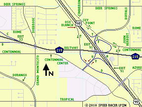
If you can update me on any more recent changes to the configuration shown above for this ever-evolving traffic interchange, please contact me.
-
Nevada S.R. 160 (Pahrump Hwy & Blue Diamond Rd) at Nevada S.R. 159 (Blue Diamond Rd)
- This is the unsignalized intersection at which Blue Diamond Road and Nevada S.R. 160 part ways in the westbound direction, with the latter continuing straight to become Pahrump Highway and the former turning right to become S.R. 159 NORTH. Sometime in 2001 or 2002, this junction became a full crossroad on highway 160, with the construction of Erskine Junction Road (which is just a one-block long street) forming the south spoke.
Please note that this intersection is now considered to be the "Las Vegas gateway point to Pahrump" for the purposes of these LPIN driving directions. In other words, this is the common point to which all alternative routes within the Las Vegas valley converge for the purposes of mileage calculations to/from Pahrump.
U.S. 95 Exit Numbering Fiasco:
Please note that the exit numbers on the U.S. 95 Expressway (soon to be Freeway) have been incorrectly assigned by the Nevada Department of Transportation (NDOT) for all interchanges between Craig Road - exit 85 in northwestern Las Vegas - and Snow Mountain (Nu-Wav Kaiv) Boulevard - exit 99 in the Las Vegas Paiute Indian Community. They do NOT reflect the actual mileage (or even their own post-mile markers) in this stretch of road, which by the way is slowly being upgraded from an expressway to full freeway status. Please note that all distances quoted here are measured from the centerpoints of each interchange in the increasing reference post direction (i.e., northbound).
For some incomprehensible reason, NDOT decided to use the number 90 for the interchange at Rancho Drive, which is the next one after Craig but acutally lies a mere 1.03 miles to the north (and not 5 miles distant as the number would imply). This interchange was recently rebuilt and partially combined with that at Ann Road. Since the Ann Rd junction is only another 0.64 miles distant, it carries the northbound designation of exit 90B rather than 91. This does makes sense IF you place post mile 90.00 at the centerpoint of the Rancho interchange, as whoever assigned these numbers obviously did (apparently without field-checking, or even map-checking them). By the way, in 2012 several of the Rancho/Ann interchange ramps will be rebuilt yet again, this time to braid them in order to eliminating weaving.
Because of the recent rebuild, southbound U.S. 95 traffic bound for Rancho Dr must now use the exit for Ann Rd (currently signed as #90). After heading straight through the (Ramp C's) signalized intersection at Ann, Rancho-bound traffic then shares Ramp D (which now functions as a distributor) with the motorists from Ann heading to southbound U.S. 95. This rebuilt ramp now spawns another (Ramp V), which then bridges the freeway and becomes southeastbound Rancho Drive.
Northbound motorists on Rancho now must also pass through a signalized intersection with Ann Road after first merging with Ramp A (which carrys vehicles exiting U.S. 95 bound for Ann) before they can proceed straight to enter the freeeway via Ramp B. By the way, Rancho was the original, pre-freeway routing of U.S. 95 (as far south as Bonanza Road) and it is currently signed as "Business Route 95", even though that designation is officially obsolete. Legally, Rancho is now Nevada S.R. 599, though that route may be decommissioned soon as well.
The next interchange to the north, currently numbered as 91, will eventually become a full "system" (freeway-to-freeway) interchange with the Las Vegas Beltway. Right now, ramp A there functions as a distributor for northbound exiting motorists. It first spawns a loop (Ramp F) to the westbound Beltway, then continues on (as ramp S) to become northbound Buffalo Drive after a signalized intersection with Sky Point Drive (a two-way frontage road along the east side of U.S. 95). The eastbound interim Beltway roadway can be currently be accessed, but only after negotiating three at-grade intersections. To do so requires two right turns followed by a left. At present, those on southbound U.S. 95 have no easy access to the Beltway in either direction at this interchange since the only current exit (Ramp C) routes traffic only to Centennial Center Boulevard. That pseudo-diagonal street connects Centennial Parkway to the west and Ann Road to the south (with a major shopping center in between).
Further north, roads that used to intersect the U.S. 95 Expressway now dead-end at its frontage roads (Sky Pointe Drive on the east side and Oso Blanca Road to the west - both of which carry two-way traffic). In 2005-2006, a new overpass was built to carry an extention of Elkhorn Road over both frontage roads and the mainline of U.S. 95. North of this point Sky Point veers away for about a mile or so, where it interfaces with and/or overlays several pre-existing arterial streets. This was done in part to accomodate the U.S. 95 interchange at Durango Drive, which is (mis-)labeled as Exit 93. The opening of this interchange also provided an interim way for southbound 95 traffic to access either direction of travel on C.R. 215, by exiting here and then proceeding south on Durango for about 1.5 miles to a diamond interchange on the Beltway (its exit #33).
About a mile and a quarter further north of the Durango exit, a new interchange was completed in late 2010 at Horse Drive, which formerly dead-ended at Sky Point (the frontage road, which by this point had resumed its parallel course along the east side of the U.S. 95 Expressway. This new interchange impacted the frontage road alignments on both sides of 95. Sky Point Dr now curves northeast into the original Horse Dr at Fort Apache Blvd, then turns left and carries the latter for a long block to a new intersection with westbound Horse (and northbound Fort Apache) just east of the interchange. Oso Blanca Rd (the west frontage road) now runs beneath the new bridge over the freeway, and Horse Drive now continues west from the interchange for about a quarter mile before ending at an extended Grand Canyon Drive. NDOT signed this new interchange as "exit 94", since the Durango Dr junction is exit 93. But since the next interchange at Snow Mountain was exit 95, but is over four and a quarter miles to the northwest, they stupidly renumbered that junction from the correct number to the illogical "exit 99". It's long past time to correct these exit numbers along all of U.S. 95! This new junction also marks the area where Las Vegas' seemingly endless urban sprawl begins to taper off somewhat, at least for the moment. If and when the economy picks back up, who knows?
Another 1.25 miles or so distant is the junction with Kyle Canyon Road, which takes S.R. 157 west to the town of Mount Charleston. Currently an at-grade cross road intersection (with a couple of stubby, turn lane style ramps in the southbound direction only), this too is proposed to be converted into a full diamond interchange (when money is finally avaliable). Once that happens, it will complete the conversion of U.S. 95 to a full freeway in this entire 10-plus mile segment, since all remaining mileage between here and the existing interchange at Snow Mountain Blvd / Paiute Way is already fully access-controlled (though the text on the signage at that exit is sub-standard since it makes no mention of the crossing road's name change).
It is unclear exactly why these exit number assignment errors occurred, but I suspect NDOT just had their heads up their collective asses on this one. As an example of this foolishness, they renumbered the Show Mountain interchange, which had been correct, because they would have run out of numbers when the Kyle Canyon Road (S.R. 157) interchange is finally built. If they simply would've corrected the mis-assigned numbers the whole problem could've been corrected once and for all.
The following table lists the current and correct (mileage-based) exit numbers for these existing interchanges and the lone remaining planned one on this stretch of U.S. 95. It also lists the "Big Green Sign" text used in signing of the current exit ramp layouts only. So please note that this does not imply the ultimate design of the Beltway interchange (currently signed as Exit 91), which will be extensively reconfigured in the near future (as it already has been several times so far), when it becomes a full system (i.e., freeway to freeway) interchange by 2014.
Currently
Signed
As
| Should Be
Numbered
As
| U.S. 95
Travel
Direction
| Current Signage Text
Text & {Shield} Correction(s) Needed:
YELLOW = Add & RED = Delete
| EXIT 85
| correct
as is
| Both
| Craig Rd
|
| EXIT 90A
| EXIT 86A
| NB
| Rancho Drive
|
| EXIT 90B
| EXIT 86B
| NB
| Ann Road
|
| EXIT 90
| EXIT 86
| SB
| Ann Road
TO {B.R. 95} SOUTH Rancho Drive
|
| EXIT 91
| EXIT 87
| NB
| {C.R. 215} WEST
Bruce Woodbury Bltwy
------------------------
Buffalo Dr NORTH
|
| EXIT 91
| EXIT 87
| SB
| Centennial Center Blvd
|
| EXIT 93
| EXIT 89
| Both
| Durango Drive
|
| EXIT 94
| EXIT 90
| Both
| Horse Dr
Grand Canyon Dr
|
not yet
built
| EXIT 92
| Both
| {S.R. 157} WEST
Kyle Canyon Rd
|
| EXIT 99
| EXIT 95
| Both
| Snow Mountain Blvd
Paiute Way
| |
Additional enhancements will be placed on this page when time allows me to research & create them.
All of the information contained herein is believed to be current as of February 07, 2012.
Copyright 2006-12 Speed Racer LPIN - For personal, non-commercial use only - contents of this webpage may not be reproduced or modified for non-personal use without express permission of Speed Racer LPIN, their author.
This page was last modified : February 07, 2012
 Southern NV